
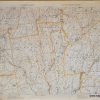

Item number: TOP113
Genuine Antique Topographical Map
1908
Maker: USGS/U.S. Geological Survey
Antique topographic map of Mt. Monadnock, New Hampshire, includes Malboro, Harrisville, Fitzwilliam, Jaffrey, Ringe, Roxbury, Nelson, lakes, ponds , railroad line, and elevations. Surveyed in 1887 and 1895. This map is an August 1908 reprint of the May 1898 edition. Good to Very good overall condition with toning throughout, and some roughing, creasing, and soiling of the outer edges of the paper. Measures approx. 17.5″ x 13″ to the neatline.
Item Number: TOP113
Related products
Sale

Camping & Hiking
Original price was: $58.76.$33.00Current price is: $33.00.
Sale

Camping & Hiking
Original price was: $21.40.$10.00Current price is: $10.00.
Sale

Camping & Hiking
Original price was: $25.00.$12.00Current price is: $12.00.
Sale

Original price was: $4,076.48.$50.00Current price is: $50.00.